-
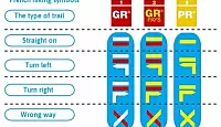
GR, GRP, PR: What do the French hiking signs mean?
What are the coloured symbols on French hiking routes? Who paints them there and why?
-
Miss France: glam - but not sexy
Miss France organiser Geneviève de Fontenay fears she is fighting a losing battle to protect her 'Cinderella dream' from vulgarity
-
Normandy Landings visit for Queen
Queen Elizabeth has confirmed a state visit to France, ending rumours she is handing over duties to Charles
Heatwave areas halved today
There are now only 16 departments on an orange alert, with the heatwave predicted to be mostly over by tomorrow
SIXTEEN departments are still on an orange heatwave alert, down from 33 yesterday.
The alert, which means people should be very careful because of potentially dangerous conditions, is maintained in the following departments: Ain, Allier, Côte-d'Or, Haute-Garonne, Isère, Loire, Lot, Nièvre, Puy-de-Dôme, Haut-Rhin, Rhône, Haute-Saône, Saône-et-Loire, Tarn, Tarn-et-Garonne and Territoire-de-Belfort.
After a sultry start to the day in many areas, the numbers of those affected by extreme heat will fall as the day goes on, with maximums of 34-37C persisting in a band from the Rhônes-Alpes to Alsace. The heat will become humid, with a risk of stormy showers in the afternoon and evening. Some stormy outbreaks are also expected in the Massif Central and Burgundy.
From the Centre to Burgundy there will be maximums of around 30-34, considerably down on the weekend and yesterday, but there will be a hot zone from the inland Midi-Pyrénées to the Auvergne (around 33-38C).
By Wednesday temperatures should have returned to around normal in most areas, apart from the lower Rhône valley and inland Provence, bringing an end to this period of canicule (heatwave).
The term canicule, meaning “little dog”, originally referred to the “dog days” of summer in July and August, a typically hot period when Sirius (“the Dog Star”), which rises and sets with the sun at this time of year, was once thought to have a heating effect on it.
Image: Météo France