-
AI photos make long-running ‘parcel for you’ scams more credible In France
Fraudsters send texts with fake parcel photos displaying your name and address
-
Niche tours create new opportunities for guides in France
Guided tourism is no longer the preserve of travel agencies, tourist offices or museums
-
‘Accidental’ Americans in France welcome lower fee to give up citizenship
Many people face administrative issues linked with being American
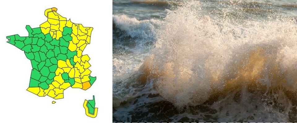
Storm Corrie and mistral: High wind alerts for north France and Var
In Var conditions could affect power and telephone lines, damage chimneys, roofs and vehicles. Branches may fall across roads and train tracks, disrupting traffic
[Update January 31 at 16:30 - the orange alert has now ended in Nord.]
The departments of Var and Nord have been placed under orange weather alerts this morning (January 31) by the national weather service Météo France.
🔶 2 dpts en #vigilanceOrange
— VigiMétéoFrance (@VigiMeteoFrance) January 31, 2022
Restez informés sur https://t.co/rJ24zzmmy4 pic.twitter.com/ZNdvstXy6K
Strong winds in Var
In Var, a mistral wind is expected to cause considerable disruption this afternoon and evening.
A mistral is a cold, dry wind which comes down the Rhône valley towards the sea at speeds of up to 130km/h.
The wind will begin building this morning and the orange weather alert will last between 14:00 and 22:00, when gusts of 90-110km/h, and even 110-130km/h at higher altitudes, are expected.
Advertisement
The wind is predicted to be particularly strong around the Sainte-Baume mountains, the Monts Toulonnais and the Massif des Maures. The coastline between Saint-Cyr and Sainte-Maxime is forecast to experience gusts of 100-120km/h.
Hautes-Alpes and Alpes de Haute Provence will also experience very high winds, of up to 100km/h.
The weather conditions could affect power and telephone lines, damage chimneys, roofs and vehicles. Branches may fall across roads and train tracks, disrupting traffic.
Residents are encouraged to secure any outdoor possessions which could be damaged or blown away by the wind. Keep up to date with the situation and avoid going out if possible.
Weather forecasting channel Chaîne Météo has also placed Aude, Bouches-du-Rhône, Pyrénées-Orientales and Vaucluse on an orange alert for strong winds.
Strong waves in Nord
Nord’s coastline is being affected by high waves as a result of storm Corrie, which has been causing considerable disruption in northern England and Scotland this weekend.
As a consequence of the storm, the North Sea sea level is significantly higher than usual, and Météo France is urging caution on the part of residents.
Over the course of the day, northwesterly winds will contribute to the unsettled sea conditions, where the tidal coefficient – the size of the tide in relation to its mean – will reach 84. People should be especially aware of the waves between 09:00 and around 13:00, when the situation should begin to improve.
As a result of the waves, roads and rail lines running alongside the coast could be disrupted, and estuary flooding could occur.
Residents should not go in the sea and should try to stay away from beaches and estuaries if possible.
Related stories
New air routes, Covid rules, port concerns: ten France travel updates