-
Surprise train strike to hit Normandy this weekend
Close to 40% of trains to destinations such as Evreux, Caen, and Rouen cancelled on Friday
-
French farmers clash with prefecture over help for firefighters
Farmers hurry to deliver water and supplies, but authorities say they must use official channels
-
World’s largest Celtic festival begins this weekend in Brittany
The 55th edition of France’s huge ‘Interceltic’ celebration is dedicated to Cornwall and the Celtic Sea
Heatwave alerts spread across west and north France, records tumble
Over 40 departments including many unaffected by August’s heatwave now face warnings
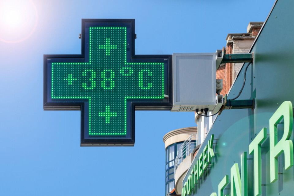
The number of departments facing heatwave warnings more than doubled overnight as temperatures across practically the entire country hit at least 30C.
As of Tuesday (September 5) morning, 43 departments, largely in the north and west of France, are facing tier-two yellow heatwave warnings.
Monday (September 4) was the hottest September day ever recorded in France, and forecasters said some parts of the country faced ‘quasi-tropical’ conditions overnight, with the temperature not dropping below 25C there.
Numerous locations recorded temperatures above 38C in the shade through the day, with one weather station even seeing 38.8C
Temperatures are expected to remain at current levels until at least Sunday with little respite as the warm Saharan winds continue to affect almost all France.
Warnings largely in north and west
Normandy and Brittany – largely untouched by August’s heatwave – now have a number of departments facing warnings, as well as Paris.
The alerts spread as far south as the Tarn-et-Garonne department, and as far east as Rhône (where Lyon is located), which was placed on red alert less than two weeks ago over the extended August heatwave.
Although all warnings for now are only at a tier-two level, they could rise if the heatwave continues.
If overnight temperatures remain high – which can prevent the cooling of homes and buildings and keep internal temperatures climbing – heatwave warnings are likely to increase.
Last night, evening temperatures in affected areas in the west and centre stayed above 20C.
In some parts of France, overnight temperatures hovered around 25C, making it difficult for people to cool themselves and their homes to sleep.
🟡 Nuit quasiment tropicale sur un certain nombre de communes de l'Ouest et du Sud de la #France ce mardi avec des températures qui ne sont pas descendues sous la barre des 20 degrés. La #chaleur s'annonce encore exceptionnelle cet après-midi ! pic.twitter.com/66Co5OJca4
— Anthony Grillon 🌪 (@AnthoGrillon) September 5, 2023
Read more: France heatwave: what to (and not to) eat and drink
Read more: France heatwave tips: How to sleep, keep cool and stay healthy
Over 200 records broken
France recorded its hottest ever September average temperature (25.1C), yesterday, which is the first time it has ever passed 25C in September, said meteorological observatory Keraunos on X (formerly Twitter).
“This is 6.1C higher than the average between 1991 – 2020,” it added.
Over 200 local records were broken across France, including in Angoulême, where the mercury peaked at 37.3C, the highest ever recorded in September.
Other record-breaking September temperatures included Poitiers (37C), Cognac (36.5C) La Rochelle (34.5C), Bourges (36C) and Niort (36.6C).
Montmorillon, in Vienne, recorded a national high of 38.8C, with a number of other places hitting above 38C.
Près de 200 stations principales ou secondaires ont battu leur record mensuel de #chaleur ce 4 septembre. Jusqu'à 39°C localement dans le centre-ouest, avec des records parfois battus avec une marge de plus de 3°C ! pic.twitter.com/lTBDJo1Mky
— Keraunos (@KeraunosObs) September 4, 2023
In Brest in Brittany, the 30.6C recorded was the hottest of the year, beating the temperatures recorded in the August heatwave.
Temperatures throughout the course of today will be between 30C – 34C across almost all the country, save for the very tip of Brittany and in pockets of the mountainous border areas.
Highs of up to 38C could be recorded again in a number of locations, particularly along the west coast and central departments.
Read more: MAP: See how hot areas of France are set to get today and tomorrow
What is the forecast for the rest of the week?
Indications from Météo France are that temperatures will hover around the same levels on Tuesday, meaning even more records could be broken.
Temperatures on Wednesday and Thursday will remain around the same – it may be minutely cooler, but not significantly so – and the rainfall expected on Saturday will not bring relief to the hottest places.
Only on Sunday (September 10) are temperatures expected to begin to cool.
Related articles:
Heatwaves: France’s housing minister backs grants to help cool homes
Return of hot weather this week in France: how hot and for how long?


