-
Neighbours take man to French court for playing same song over and over
Noise complaints are not uncommon in French towns and villages.
-
Where are the healthiest places to live in France?
New survey compares nearly 1,000 municipalities, west and south rank highest
-
Is the EU set to relax September’s strict EES implementation?
Nine countries, including France, have asked for greater flexibility
Orange skies return as Sahara sand dust blown across south west France
The phenomenon will affect the Pyrenees and much of Occitanie. Rain is also expected meaning the sand particles will fall with it in some areas
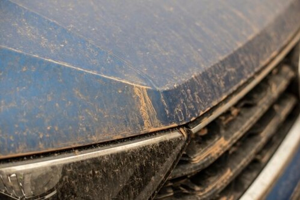
An episode of Sahara sand dust is set to return to France this week as the orange mist is forecast to be blown across the southwest of the country today (Tuesday, February 21).
The sand, which is blown up from the Sahara via wind currents, has been seen over Spain in the past few days and is set to arrive in the southwest, mainly in the Occitanie region.
Guillaume Jusseau, from specialist weather site Météo Contact, told La Dépeche yesterday: “An anomaly at altitude above the Maghreb (northern Africa) will push Sahara sand towards us from tomorrow.”
⏳Une anomalie d'altitude placée au large du Maghreb, va nous propulser du #sable du #Sahara dès demain. Donnant des pluies chargées (modérément) en sable, agglomérée aux polluants dans l'air provoquant possiblement la contamination des sols & sources d'💧.pic.twitter.com/xK5esZAFk8
— Guillaume Jauseau (@GJauseau) February 20, 2023
And although the phenomenon typically brings remarkable orange skies, it is also expected to bring rain that is moderately full of dust particles, which can mix with existing air pollution to cause contamination of the soil, and water sources.
Residents are advised to cover any outdoor water sources and to wait until the phenomenon has passed before washing outdoor furniture or vehicles parked outdoors.
🔴 Les remontées de #sable du #Sahara se confirment par le sud-ouest de l'#Europe en ce début de semaine. La #France sera surtout impactée entre mardi et jeudi, d'autant plus que la #pluie reviendra mercredi. Ne nettoyez pas votre véhicule durant cette période ! ⚠ pic.twitter.com/ftpZBfWeta
— Anthony Grillon 🌪 (@AnthoGrillon) February 19, 2023
The dust can also cause respiratory issues for anyone predisposed to them so people in affected areas are also advised to take extra care outdoors during the episode.
The phenomenon is relatively common, especially at this time of year (although last year it also happened in October). It has happened fairly regularly over the past two years, and even coloured ski slopes with an orange tint as it moved across the mountains.
In February 2021, scientists in Toulouse and Grenoble called for samples of snow with flecks of the sand, to help with their environmental studies.
Related articles
Orange skies on way again as winds bring Saharan sand to France


