-
‘Village of cats’ in southern France is inspired by an old legend
Story of a young girl and her kittens has influenced the architecture of La Romieu, classified one of the Plus Beaux Villages de France
-
When and why do we say c'est la sardine qui a bouché le port de Marseille?
Marseille, a ship, a very big sardine, and a stereotype
-
Hungry, peckish, stuffed: 11 French phrases to do with food and eating
These phrases help to talk about one of the most important subjects in France - food
Five French facts: The historic and unofficial geography of France
Forget administrative boundaries, these are the cultural and psychological identities of the Hexagon
This variegated and complex country could be said to have two intersecting human geographies: the official and the unofficial; one prosaic, the other imaginary.
The former is divided into administrative departments and regions with precise boundaries.
The latter is best described as a psychological concept, a combination of folk memory and the physical divisions of the landscape.
Here are five parts of France that are cultural, geographic and tourist designations rather than addresses the post office will deliver to.
They exist and do not exist at the same time.
1. The Midi
The bottom third of France – roughly everything under a line drawn from Bordeaux to Briançon along the 45th parallel north – is colloquially known by this name which comes from the old French word for “midday”, when the sun was due south.
It is more or less synonymous with Occitanie (in the linguistic and cultural sense; not to be confused with the modern political region) where Occitan is traditionally spoken.
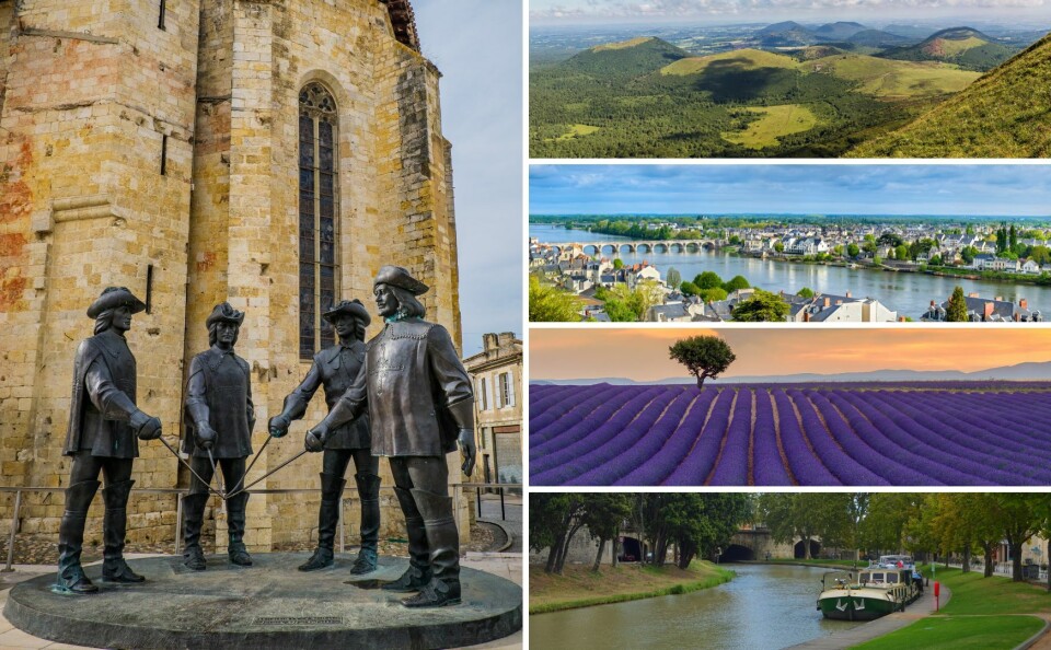
2. Gascony
Tourist promoters and estate agents love this evocative name which conjures up images of bucolic living, and the Three Musketeers.
Gascogne was an ancient province of France that was swallowed up by the kingdom of Aquitaine in the 11th century.
If there is such a thing as Gascony today it consists mostly of the Gers department together with a little of the Landes and part of the north of Hautes-Pyrénées.
3. Provence
It may be the “south of France” that everyone writes home about but it is really a historical province of France that no longer exists.
On a prosaic level the southeast of the country nudging up to the Mediterranean is now described by the mouthful of Provence-Alpes-Côte d’Azur (PACA) while incorporating a little bit of Auvergne-Rhône-Alpes.
Read more: Marseille’s metro to start making announcements in Provençal
Read more: Provençal pronunciation: How does it differ from standard French?
4. The Loire Valley
The French don’t generally use the name Val de Loire for the lower-middle valley of the longest river entirely flowing through France in the same way as English speakers do.
The declaration of a World Heritage Site covering that part of the valley studded with royal and aristocratic chateaux has given it more definition but in reality it is a composite of two regions, four departments and a host of ancien régime fiefdoms – especially Anjou, Touraine, the Blésois and the Orléanais.
5. The Massif Central
It is, of course, a highland region of mountains and plateaux in the middle of France.
It covers 15% of metropolitan France and is hard to avoid.
It only became a thing, however, in the 19th century when the name was coined.
Its eastern edge is marked by the Rhône valley but to the north, west and east it peters out unspectacularly.
There is not much unifying the five regions and 11 departments that have a stake in the Massif Central except this rather loose geographical term.
Related articles
14 words that change dependent on where you are in France
LISTEN: Click map allows you to hear 75 local languages of France


