-
Neighbours take man to French court for playing same song over and over
Noise complaints are not uncommon in French towns and villages.
-
Where are the healthiest places to live in France?
New survey compares nearly 1,000 municipalities, west and south rank highest
-
Is the EU set to relax September’s strict EES implementation?
Nine countries, including France, have asked for greater flexibility
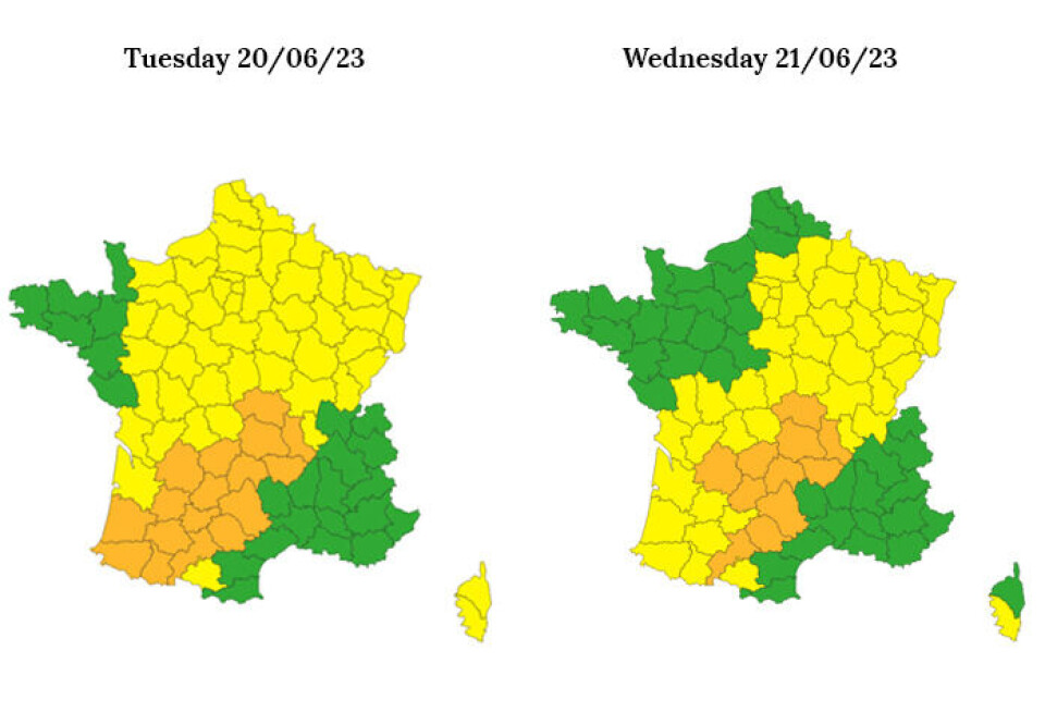
More than two-thirds of France on alert over yet more stormy weather
Only the north-west and south-east have escaped warnings
The majority of France is yet again on alert for stormy weather over the next two days.
After heavy rain, high winds and hail lashed parts of the country on Sunday (June 18) and Monday (June 19), that trend looks set to continue.
Storms will sweep across the country from the south-west to the north-east, according to weather forecasts.
A first wave will see them move up from Nouvelle-Aquitaine on Tuesday (June 20) morning, crossing Paris and reaching the Hauts-de-France by mid-afternoon, according to a graphic shared by meteorologist Guillaume Séchet.
Then by late afternoon, more storms will cross the Pyrenees, southern central France before arriving in eastern departments overnight on Tuesday/Wednesday.
⚡ Nouvelle journée à risque d'#orages violents ce 20 juin 2023, dès ce matin puis en après-midi de l'#Aquitaine aux #HautsDeFrance puis ce soir et cette nuit des #Pyrénées jusqu'en #Alsace. #Grêle et rafales de vent sont redoutées. (via @wxcharts) pic.twitter.com/DPYE514ymg
— Guillaume Séchet (@Meteovilles) June 20, 2023
France’s national weather forecaster, Météo France, says 72 French departments have been put on alert on Tuesday.
The swathe of departments on warnings runs across the country diagonally, from the south-west to the north-east. Only the north-west and south-east corners of France are spared.
They had initially all been put on a level-two yellow alert, which advises people to be cautious when outside and to keep up to date with weather forecasts. However, on Tuesday morning, 17 departments - mainly in the south-west of France - were upgraded to a more serious orange alert, the second highest. This urges those affected to be extremely vigilant of dangerous weather.
Weather warnings for Wednesday (June 21) are similar, with 58 departments issued with a warning, including 11 with an orange one.
Related articles
Floods, hail and… a tornado? Storms lash large swathes of France
France storm warnings continue: tips on how to secure your property


