-
Final days to take advantage of France’s summer sales
The original dates were extended
-
Brittany beach ranked among the world’s most beautiful - but you cannot visit
Visitors entering the turquoise shoreline risk a fine
-
Normandy D-Day beaches gain UNESCO World Heritage status
Cathar castles also added as ‘Royal Fortresses of Languedoc’
Stay home warning as red flood alerts continue in north France
Another barrage of rain is expected to hit over the 24 hours
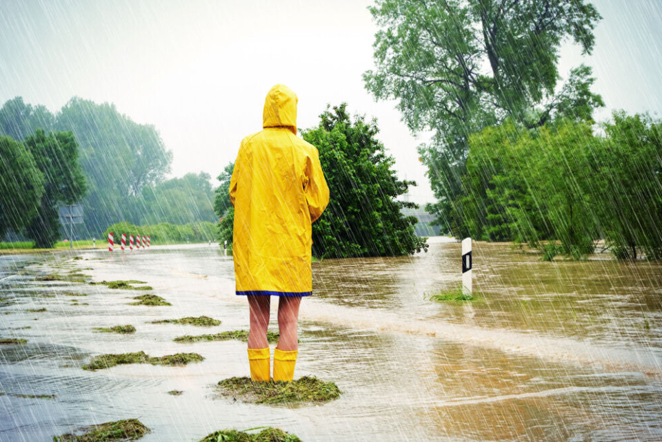
The Pas-de-Calais department in the north of France is again facing red alert warnings for river flooding – as well as heavy rains – as downpours continue.
It comes after the department was placed on red alert for river flooding earlier this week when the Aa and Liane rivers burst their banks.
The two rivers are impacted again as are the Hem and Canche rivers.
In addition, a red alert for heavy rainfall is in place from 14:00 on Thursday (November 9), lasting until at least 06:00 on Friday morning.
Schools in 200 communes will stay closed until the end of the week annoucned Interior Minister Gérald Darmanin, and transport continues to be affected.
The neighbouring Nord and Somme departments are on a heightened alert for heavy rain (as is the nearby Seine-Maritime)
Up to six months of rain have fallen in less than a month across some northern areas, largely caused by the heavy passage of Storms Ciaran and Domingos, leaving soils saturated.
The west of France is also still facing a number of alerts for stormy weather, heavy rain, river flooding, and strong winds - see below.
Flooding alerts raised again
An update from the Pas-de-Calais prefecture this morning stated that over 5,000 homes were without running water, and almost 50 without electricity, due to the floods.
The prefecture shared advice for residents via a post on their X (formerly Twitter) page.
#VigilanceCrues 🔴
— Préfet Pas-de-Calais 🇫🇷🇪🇺 (@Prefet62) November 9, 2023
Les cours d'eau de #Liane et l'#Aa sont de nouveau placés en vigilance rouge #crues par @Vigicrues à compter de 6h.
Soyez extrêmement prudents. pic.twitter.com/LPSgnVW7nl
Advice includes staying inside and preparing your property in case it gets hit by a flood (moving objects susceptible to flooding such as electronics, or toxic products, to higher ground).
Read more: What to do (and not do) during heavy rain and flood alerts in France
Problems prolonged by rain
“There will be small lulls between two spells of rain, but [it will fall] much steadier this afternoon,” and could continue into the weekend, said meteorologist Patrick Marlière.
It is “a worrying situation… flooding is almost inevitable,” he added.
Meteorologists are predicting up to 100 mm of rain could fall between this morning and Friday afternoon.
Western France still facing warnings
Despite predictions yesterday that the number of departments facing warnings in the west of France would fall to below 10, many departments are still facing alerts.
The Charente-Maritime is facing a heightened alert (for river flooding along the Boutonne), but almost 30 others face tier-two yellow warnings.
In the east, the first warnings of the winter season for black ice/icy roads in Hautes-Alpes and Alpes-de-Haute-Provence are present today.
You can keep up to date with all weather warnings on the official Météo Francewebsite.
Tomorrow, the north-west of France will face warnings for strong winds, however in the south-west almost no alerts are expected (except for coastal wave warnings).
Note that alerts can change - those still present in the west, for example, were due to be lifted as early as Tuesday morning.
Related articles
Watch out for fake officials and aid scams after storms in France