-
Meat withdrawn from French supermarkets over E.Coli risk
Lidl and Super U among stores selling potentially impacted ground beef
-
Ryanair becomes most popular carrier at Toulouse airport
Several low-cost carriers are targeting the French city with route expansions
-
New reports of Britons missing flights due to EES delays
Queues of several hours reported in Spain prior to full EES rollout
Sun, storms and heatwaves: Weather outlook for France this weekend
Heavy rain is expected to hit the north-east on Saturday, while heatwave alerts have been issued for five departments in the southern half of France
Areas of northern France are expected to be hit by storms, while the south will see warm sunny weather with heatwave conditions in some parts.
That is the broad outlook for the start of what will be a long weekend for some.
With Tuesday (August 15) a bank holiday - or jour férié - in France, many will take Monday (August 14) off work to faire le pont and enjoy a long weekend.
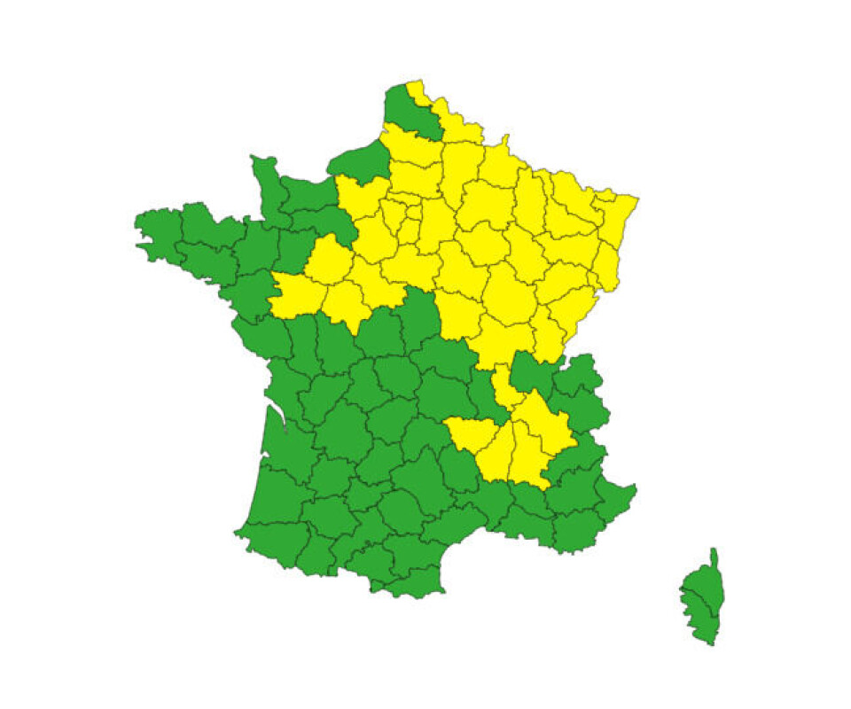
On Saturday (August 12), 37 departments are facing storm weather warnings, as heavy rainfall is expected in the east of France.
In the south of France, however, temperatures are expected to remain extremely warm and could reach highs of 38c in the Rhône valley.
On top of this, five departments are facing warnings for canicule, or heatwave throughout the weekend.
Most of the rain will clear by Sunday (August 13) and be replaced with cloudy weather, but the south will continue to see warmer temperatures, with no respite until potentially the end of next weekend (around August 20).
Weather expert Yann Amice predicts the south-west could once again see temperatures of 40C next week, on or after the public holiday.
Friday evening sees storms sweeping in
This afternoon (August 11), clouds are expected to roll in from the Atlantic and Brittany coasts, before breaking into heavy rainfall and impacting a number of northern departments
Throughout the evening and overnight, there will be 23 departments facing tier-two storm warnings, running roughly from Loire-Atlantique (Nantes) to Paris and the surrounding departments, as far north as Aisne.
You can find a full list of departments facing the warnings for Friday on Météo France’s website here.
Elsewhere, temperatures in the south will continue to be high, with the mercury reaching 34C on the Atlantic coastline, and between 36C and 38C in the Rhône valley – a temperature that will persist throughout the weekend.
Five departments in this area (Isère, Rhône, Drôme, Ardèche, Haute-Loire) are facing tier-two canicule warnings – meaning temperatures do not lower during the evening, keeping the overall temperature high.
Saturday storm warnings increase
The stormy weather is set to blow eastwards into Saturday, where all departments in the north-east of France will face tier-two, yellow storm warnings.
The storm will become particularly strong in the afternoon, warns Météo France.
You can see a map below of the areas currently facing warnings for Saturday.

Credit: Météo France
On top of this, the heatwave warnings for the five departments around the Rhône Valley will continue.
Elsewhere, particularly on the Mediterranean coastline, sunny skies and average summer temperatures are expected – welcome news for those holidaying in the area.
Read more: Concern amid record temperatures in the Mediterranean Sea
More high temperatures coming next week
By Sunday, the storms are expected to dissipate and be replaced with cloudy skies, although a few patches of rain will still appear.
The high temperatures will continue, and could even reach 40C, according to some meteorologists.
In particular, temperatures from August 15 (the Assumption public holiday) to the end of next weekend will be high, with a potential heatwave on the way.
Tendance météo à partir des ensembles.A compter du 15, retour du très chaud sur toute la France.
— Amice (@Yann_amice) August 10, 2023
Le Sud-est dans ce schéma apparait beaucoup plus exposé aux fortes chaleurs
Modèle européen du 10 au 21 aout
Anomalies de température à 850 hPa.@weathernco pic.twitter.com/d6UPePoCDN
The extended hot weather will do little to assuage fears over drought restrictions, which have seen over 30 departments now be hit with ‘crisis’ warnings in at least one department
Related articles
Warmer summer? Météo France gives three-month weather trends outlook
‘Face the reality’: France ‘must prepare’ for +4C global warming


