-
Readers reveal what worked to stop ants invading their homes
Simple, practical suggestions from readers after this summer's surge in household ant invasions
-
Can a 300-year-old yew survive France’s changing climate?
A veteran tree owner is asking experts for help after extreme heat damaged a centuries-old yew
-
Monaco welcomed 6.7 million visitors in 2025: US and UK among its top international markets
Most visitors are ‘same-day’, but overnight visitors account for the majority of Monaco’s tourism spending
COP26: New map shows 20% of French coast at risk from erosion
Regions with sandy coasts are most at risk, data shows, with estimates suggesting that by 2100, as many as 47,000 homes could be affected
Almost 20% of the French coastline is threatened by erosion and rising sea levels, a new interactive map shows, as climate change conference COP26 opens in Glasgow today (Sunday, October 31).
The interactive map, compiled by FranceInfo, shows exactly how this will affect the French coastal landscape.
Using data from the Centre d'études et d'expertise sur les risques, l'environnement, la mobilité et l'aménagement (Cerema), experts compared aerial images dating from the 1930s to 1950s with more recent photos.
It shows that almost 20% (18.6%) of France’s coastline, or 900km, is ‘retreating’. So far, a total of 523 communes will "have at least one sector affected".
And the 59 most-affected municipalities may experience as much as 1.5 metres of erosion per year on average.
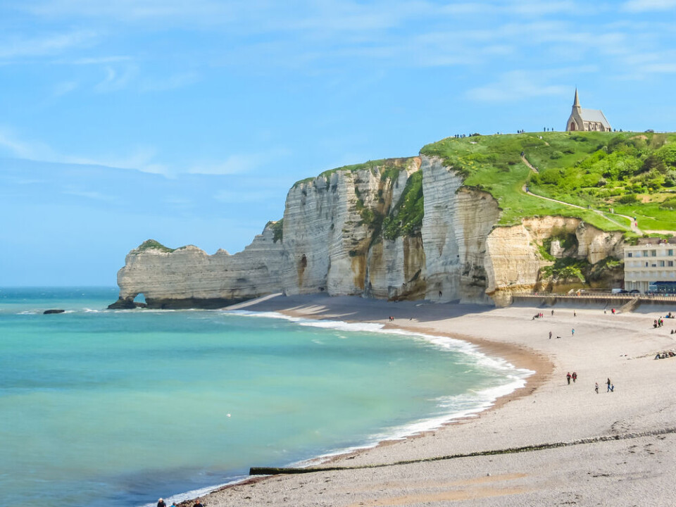
Advanced erosion on sandy coasts
Regions with sandy coasts (41% of the coastline) are the most affected by a change in the coastline: 37% are experiencing a retreat, 23% an advance.
In areas with cliffs and rocky coasts (54% of the coastline), 6% of the coastline is affected by a retreat.
The scenarios are pessimistic: by 2100, between 5,000 and 47,300 homes could be victims of erosion according to Cerema, and the cost would be as much as €8 billion.
Gironde, Manche and Charente-Maritime, which have long sandy beaches, are the departments most affected. The erosion will mean a loss of 30 km2 in 50 years in Gironde, and the south of the island of Oléron, in Charente-Maritime.
Some specific communes are also particularly affected: this is the case of La Tremblade (Charente-Maritime), where some dunes have retreated by 7.9 metres per year between 1945 and 2010.
But while no homes are yet at risk in La Tremblade, this is not the case in communes such as Soulac-sur-Mer (Gironde), where a residential building built 200 metres from the sea in the 1970s was evacuated in 2014 due to erosion and storms.
The coastline there retreated by 4.3 metres per year between 1957 and 2013, and by more than 30 metres in one go during the winter of 2013-2014.
In 2016, Aquitaine coast monitor l’Observatoire de la côte Aquitaine predicted that the coastline would be eroded by 50 metres by 2050. In some places, such as the Gâvres peninsula, near Lorient (Morbihan), erosion is threatening vital infrastructure – in this case, the only access road to the town.
Near Béziers, concern is growing at Valras-Plage (Hérault). Its barrier, which was built in 1995 to contain the sand, is no longer playing its role.
Philippe Barbet, director of the water cycle at the Béziers-Méditerranée Agglomeration, told Midi Libre on October 29: "It is worsening the erosion of the beach in this marine submersion zone.”
Solutions are being considered to stop the process, as the beach is shrinking day by day.
A new project in Normandy
In Quiberville, Seine-Maritime, authorities are choosing another approach, and are embarking on an unprecedented project, supported by the European Union and the government, to ‘let the sea into town’.
Instead of erecting walls and barriers, the municipality is letting the ocean enter the land, with the beach and coastline ‘rearranged’ accordingly.
Since 2017, other similar projects, dubbed "flexible management of the coastline", have been carried out in France, initiated by coastline group la Conservatoire du littoral.
Professor Stéphane Costa, a researcher at French research centre CNRS, has been studying the retreat of the coastline in Normandy for thirty years, and he believes that global warming will worsen the issue.
He told France 24 on October 28: "The village is already threatened by submersion on the seaside and flooding from the Saâne on the land side. In the higher areas, we must also face the problem of erosion.”
Concerns for archaeological sites
In some regions in France, climate change may even threaten some archaeological sites on the coast, reported Le Figaro on October 22.
The most sensitive sectors are located on the sandy Atlantic coast, and in the French overseas territories.
Discussions on how to prevent this damage were held earlier this month, at an event organised by the National Institute of Preventive Archaeology (Inrap), at the Quai Branly Museum in Paris on October 20 and 21.
Advancing coastline in some areas
In contrast, in some places, the coastline is ‘advancing’, such as at Grau-du-Roi in the Gard region.
In some parts of the area, the coastline has risen by more than 15 metres per year between 1937 and 2011, due to the construction of a port and a dam, which has encouraged the accumulation of sand.
Related stories
Var joins three French departments on orange alert for rain and floods
Netflix’s Lupin and Covid have made our Normandy tourist town ‘hell’
Owners lose out in erosion battle


