-
Paris metro to introduce contactless payments
The move aims to make buying tickets faster and easier during peak travel seasons
-
100,000 discounted SNCF train tickets for August go on sale
The three-day flash sale offers second-class fares for €19 and first-class for €29 across TGV INOUI and OUIGO services
-
List: who is officially running in the 2027 French presidential election?
Socialist mayor is latest to announce candidature bringing number to 18
How hot will France’s heatwave be and how long will it last?
Temperatures of above 30C are expected across the whole country. Some areas may be placed on red heatwave alert
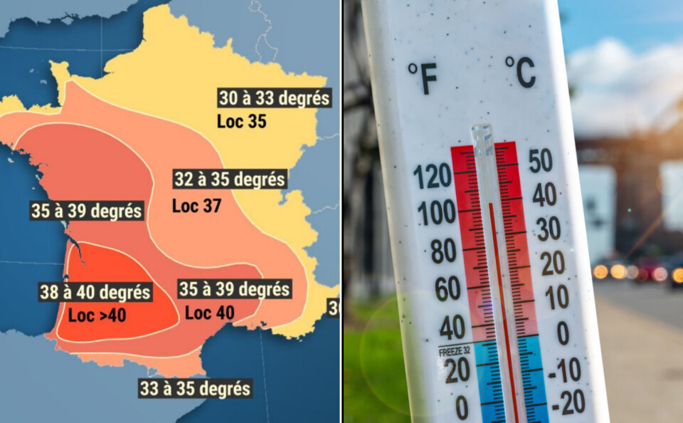
France is heading for a week of record-breaking temperatures that could climb to over 40C in places.
Météo-France describes the heatwave as “remarkable” for how early in the year it is, saying that it could become the earliest heatwave in France measured on a national level since recordings began in 1947.
The previous earliest heatwave was between June 18 and 22, 2017.
Read more:Do May's high temperatures indicate a hot summer ahead?
There are currently 12 French departments, mainly in the south-west of the country, on yellow heatwave alert. These are:
Gironde, Landes, Pyrénées-Atlantiques, Hautes-Pyrénées, Gers, Lot-et-Garonne, Haute-Garonne, Tarn, Tarn-et-Garonne, Aveyron, Ardèche and Drôme.
Météo-France has said that this week the orange alert limit could be reached or even surpassed with some places being placed on red alert.
The alert system is linked to France’s ‘plan canicule’, which you can read about here: France’s ‘heatwave plan’ and how it may affect residents.
Météo-France updates its alert map at 06:00 and 16:00 every day, or when necessary, based on changing events.
You can see heatwave alerts in your department at this link.
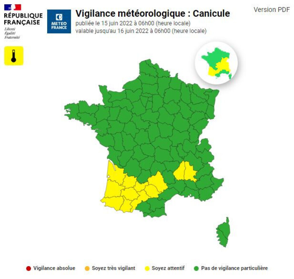
12 departments are on yellow alert for heat waves (June 15). Pic:Météo-France
Vague de #chaleur | Connaissez-vous le dispositif de vigilance mis en place ?
— Ministère de la Santé (@Sante_Gouv) June 14, 2022
💡On vous le présente sur : https://t.co/z9aQTkGenu
🔎 Restez informé avec la carte de vigilance de @meteofrance sur : https://t.co/My9FJxUEvZ pic.twitter.com/lWsNx5l4YC
When will the heatwave peak?
Temperatures are already high in many parts of France but this current heatwave is expected to begin on Wednesday coming up from the south-west of the country.
The peak is expected between Thursday and Saturday, with temperatures varying around the country but likely at some stage to surpass 30C everywhere.
In the north, for example, temperatures are expected to break the 30C barrier from Friday.
The highest temperatures will be in the south, south-west and west of the country, where they could reach up to or even exceed 40C.
Overnight, temperatures are likely to remain 20C or higher in many places.
une #VagueDeChaleur intense et précoce se met en place ce milieu de semaine. Vendredi : >30°C partout et loc. >40°C dans un quart sud-ouest. Des vigilances #canicule niveau 1 (jaune) sont initiées dès ce soir dans le sud du pays. Restez informés https://t.co/BeTAGzRLBH pic.twitter.com/vkv3JcGu7N
— VigiMétéoFrance (@VigiMeteoFrance) June 14, 2022
Read more:What can we expect from the heatwave about to hit France?
When will the heatwave end?
Météo-France is predicting temperatures to fall on Sunday (June 19) after a storm that will begin over the Atlantic coast.
It means temperatures should be lower from next Monday, although it could still be over 30C in parts of the south-west of the country.
How to keep cool during a heatwave?
France’s national health agency, Santé publique France, offers the following advice to people to help manage heatwaves.
- Stay out of the sun
- Drink water
- Avoid alcohol
- Eat sufficient amounts of food to maintain energy levels
- Close windows and shutters during the day, aerate rooms during the night
- Spray yourself with water to keep cool
- Keep in touch with friends and family, especially those who are vulnerable
- Consider doing low-energy activities
🌡️ Santé publique France rappelle les conseils et gestes simples à adopter par tous pour se protéger des fortes chaleurs 👇 https://t.co/8VUWHJBNJv pic.twitter.com/GdYg5eXxKO
— SantépubliqueFrance (@SantePubliqueFr) June 13, 2022
What qualifies as a heatwave in France?
The term “heatwave” in English is applied more generally to any period when temperatures feel higher than usual.
In France, meteorologists will declare a “canicule” if temperatures exceed expected levels for the time of year during the day and stay high at night for a period of at least three consecutive days.
The temperature thresholds depend on the region. Paris would be classed as being in the midst of a canicule if the temperature is higher than 31C during the day and 21C at night for more than three days, but in Marseille this label would only be applied for highs of 36C and 24C.
Another reason for the lack of fixed canicule temperatures is that certain meteorological conditions can make the air feel hotter and more humid than it actually is, increasing the effect on the general public.
Related stories
2,000 campers evacuated as forest fires break out in south of France
France declares state of ‘catastrophe naturelle’ for early June storms


