
-
France fuel shortages: the situation department by department
Significant shortages persist in Ariège, Indre-et-Loire and Puy-de-Dôme among others
-
EES: Lack of equipment stalls checks for cross-Channel travellers
Biometric data collection will not start for most ferry or Eurostar passengers despite EU deadline
-
Family honours daughter’s memory with book donations to French schools
Hannah Jones, who died in a road collision, has inspired art and a charity
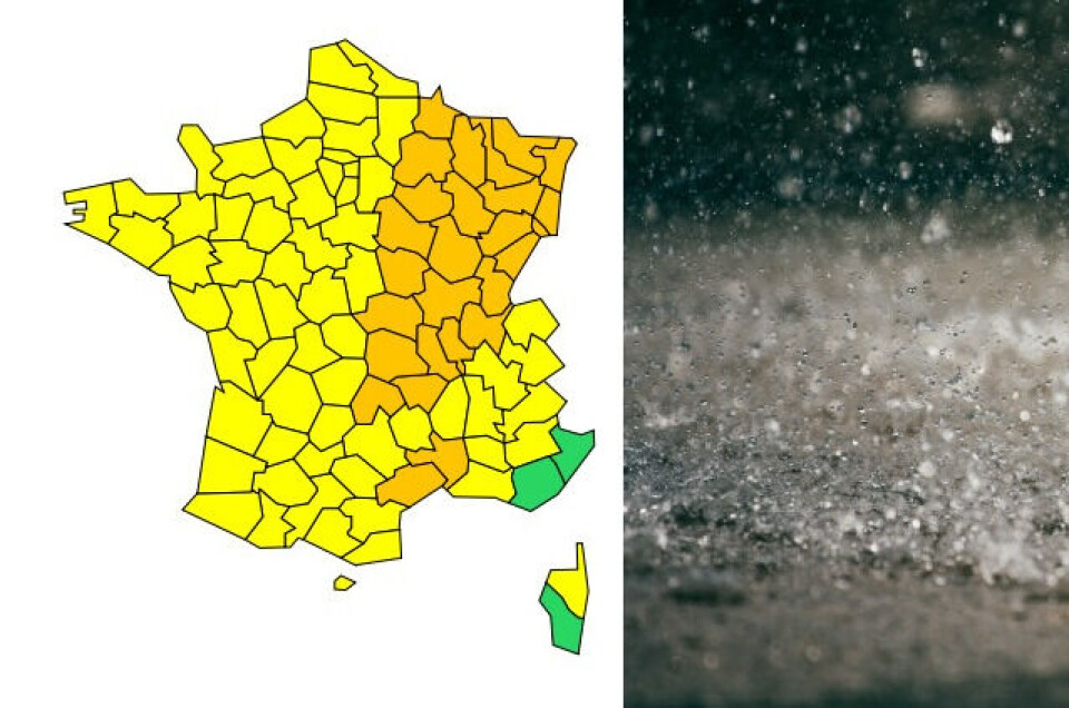
Storm alerts for 27 central, eastern and southern French departments
Gard and Hérault are also under an orange warning for heavy rain and potential flash floods
[Article updated on September 6 at 10:45 as new departments were added to the alert.]
There are now 27 departments in the centre, east and south of France under orange weather alerts for storms and/or potential flash flooding today (September 6).
The departments placed under storm alert at 06:00 this morning were: Ain, Allier, Cantal, Côte d’Or, Doubs, Gard, Hérault, Jura, Loire, Haute-Loire, Nièvre, Puy-de-Dôme, Rhône, Haute-Saône, Saône-et-Loire, Yonne and Territoire de Belfort.
They were joined by Ardennes, Aube, Marne, Haute-Marne, Meurthe-et-Moselle, Meuse, Moselle, Bas-Rhin, Haut-Rhin and Vosges later in the morning.
🔶 27 dpts en #vigilanceOrange
— VigiMétéoFrance (@VigiMeteoFrance) September 6, 2022
Restez informés sur https://t.co/rJ24zzmmy4 pic.twitter.com/123XoBAZBK
Gard and Hérault are also under an orange warning for heavy rain and the potential for flash floods.
Some of these departments have been under an orange alert since yesterday afternoon (September 5).
A further 66 departments – covering all but the far south-east – are under yellow alerts for storms.
The storms have not begun yet, but showers are beginning to occur in Gard and Hérault. Central and eastern areas will see the storms arrive this afternoon.
“There is a marked uncertainty in terms of the timescale and location [of the storm],” national forecasting service Météo France stated.
“However, the risk that it will linger is high. The episode could continue on Tuesday night, and on Wednesday as well.”
Advertisement
Météo France added that “there is a significant risk of very heavy rainfall over a short amount of time, typically around 80mm in less than three hours.”
In Gard and Hérault, 100-150mm of rain could come down in some areas.
Hail and strong gusts of wind of up to 100km/h are also expected.
Related articles
Hot summer boosts gecko numbers in south-west France
Dordogne town battered by hail is left in limbo by French insurers
80% of people in France to see 16-29 abnormally hot days each year


