-
Skier who killed five-year-old British girl in collision convicted of manslaughter
The crash happened on a blue slope in Flaine in 2022
-
New French airline will diversify and offer more domestic travel options
The new airline is scheduled to launch in the first quarter of 2027
-
Winds up to 120km/h set to hit France - see which regions will be impacted
Thunderstorms forecast in several areas over the bank holiday weekend
Temperatures in France to peak today at 36C, but no heatwave declared
After highs today in the south west, storms are expected in the area tonight before widespread cooler temperatures and rains tomorrow
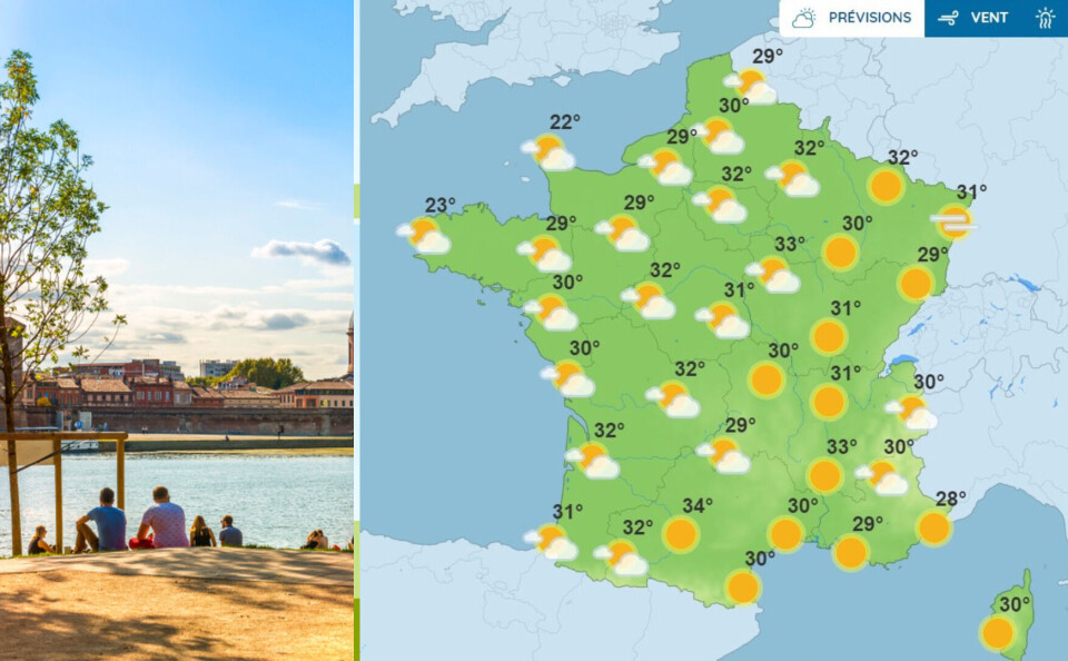
This afternoon (August 24) is set to be the hottest day of the week with high temperatures around the majority of France, including peaks of 36C around Toulouse and the south west.
Temperatures in France began to creep back up last weekend after a stormy period and will peak today.
French weather service Météo-France has said that this week’s temperatures are “well above seasonal norms” but as the “episode will be short-lived”, it cannot be classified as another heatwave.
In France, a canicule (heatwave) is only declared if temperatures exceed expected levels for the time of year during the day and stay high at night for at least three consecutive days.
The hottest temperatures today will be this afternoon in the south-west of the country in Nouvelle-Aquitaine and Occitanie.
In much of the rest of the country, temperatures will be around 30C.
The exception is parts of Brittany, with highs of 23C predicted in Brest, and in Normandy, with 22C expected in Cherbourg-en-Cotentin.
After this afternoon’s highs, storms are expected tonight in the south-west, over the Pyrénées-Atlantiques and the Hautes-Pyrénées.
This will lead to rains around much of the west of the country on Thursday, and cooler temperatures elsewhere.
The whole of the west coast of France is on yellow storm alert today. This is the second alert level of four and means people should “be attentive”, but do not need to take any particular precautions.
Related articles
What’s coming up? The week ahead in France


