-
Fête de la Musique 2026: France's nationwide music festival this Sunday
Up to five million people are expected to take part, enjoying free concerts and late-night transport
-
Anti-obesity drugs Wegovy and Mounjaro reimbursed in France from Monday
Eligible patients will now receive partial coverage under strict medical criteria
-
Hot spell returns to France with highs of 35C forecast in the south
Temperatures are forecast to reach between six and eight degrees above seasonal norms in some areas
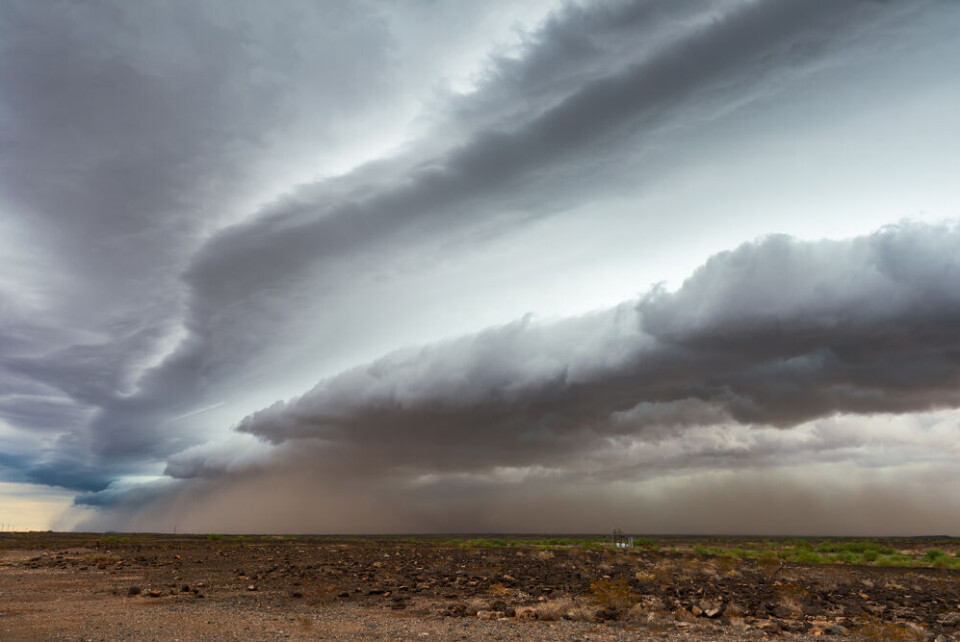
Corsica’s fatal storm: Why did alert warnings come so late?
A rare, arched cloud formation signalled the arrival of the violent and sudden storm. We look at how storms are forecast and what went wrong
A storm warning in Corsica was only upgraded to orange - the second highest alert level - moments before a huge violent storm battered the island yesterday morning (August 18), leaving five people dead and 20 injured.
Among the dead was a 13-year old girl.
Read more:Girl of 13 among five killed as surprise storms batter Corsica
It was not until after 08:00 that France’s national weather service, Météo-France, upgraded the alert for both Corsican departments from yellow to orange.
This was after winds of over 200km/h had been recorded at local weather stations.
The sudden and violent storm passed over the island quickly, leaving behind a trail of damage. By 11:00, Météo-France had again downgraded the alert to yellow. Later on Thursday afternoon it was again placed on orange alert, which is still in place now.
#Corse Une rafale exceptionnelle 224 km/h vient d'être mesurée à la station de Marignana sur une partie exposée de la côte ouest, 131 km/h à Ajaccio ! La #Corse passe en #vigilanceOrange immédiatement ! Soyez prudents, également pour autres aléas liés aux #orages.
— VigiMétéoFrance (@VigiMeteoFrance) August 18, 2022
Read more:Hail, floods, 224km/h winds: Five die as storms batter France
Read more:France storms: What to do (and what not to do) to stay safe
The reason the island was not placed on orange alert sooner was because forecasting models showed that the storm would most likely hit the sea, Météo-France states.
Local préfectures were warned on Wednesday that coastal areas could be affected and gusts of up to 100km/h could hit the island.
“Winds of over 200 km/h were recorded, which is quite exceptional for a storm,'' said Christophe Morel, head of the forecasting department at Météo-France.
"We can say that we were a little surprised by these numbers, which have never been observed before.”
The problem is that thunderstorms are particularly difficult to forecast as they occur on small scales. Météo-France uses a tool called Arome to create forecast models, which is operated by a supercomputer in Toulouse. These models are updated every three to six hours.
Some meteorologists, such as Guillaume Séchet, pointed out on social media that one model did in fact predict more or less accurately the storm that hit Corsica.
#Corse #tempête Le modèle AROME avait prévu cette tempête pour ce matin dés le scénario d'hier 6h et surtout à partir de celui d'hier 12h (mais pas encore très bien calé). Voici le scénario publié cette nuit 0h : les zones touchées sont quasiment les mêmes ! carte @meteociel pic.twitter.com/nQnNtFOY8E
— Guillaume Séchet (@Meteovilles) August 18, 2022
Météo-France has stated that proceeding models showed a different result and appeared to be more likely.
François Gourand, a forecasting engineer, said there are limits to what weather forecasts can detect.
He said that other simulations yesterday showed the storm further out to sea.
"If we put orange warnings in place for each very serious simulation, we would have the whole of France on an orange warning," he said.
He said that yellow alerts also forewarn the possibility of serious local storms.
Philippe Arbogast, scientific researcher at Météo-France, says he understands the criticisms against the weather service, but said that it is important to find a balance when doing forecasts between “not missing elements and not over-alerting people”.
#Corse : Météo France questionnée après avoir déclenché l'alerte orange seulement quelques minutes avant les rafales à plus de 200 km/h 🔴 (@infofrance2) pic.twitter.com/55AXhHpFbB
— Telematin (@telematin) August 19, 2022
What caused the freak Corsican storm?
Moments before the storm hit, a huge and foreboding cloud formation could be seen advancing towards the island.
This was an arcus cloud.
Violent summer storms have swept parts of central and southern Europe, causing casualties.
— World Meteorological Organization (@WMO) August 19, 2022
Photo of Arcus cloud over island of Corsica, which saw wind gusts up to 225 km/h Thursday, per @meteofrance
📸 Paolini Photography#EarlyWarningEarlyAction pic.twitter.com/ea7tyVIYwT
French weather specialist Loïc Spadofora said that an arcus is essentially a line of thunderstorms.
He said that the cloud like the one that formed over Corsica is not unprecedented, “but it has been a long time since there was such a clear one on the territory”.
“The cloud is formed by a contrast of temperatures, a conflict of air masses", he told BFMTV.
“It will be visible as soon as there is atmospheric instability, or as soon as there are cumulus or cumulonimbus clouds.
“It is the southeast of France that is the most exposed to cumulonimbus clouds.
“The fact that the Mediterranean Sea is extremely hot at the moment generates a lot of atmospheric instability.
“It is this instability that acts as fuel for the storms: the greater the instability, the more powerful and violent they are.”
Related stories
We must prepare homes now for flash floods, says French fire chief
June flooding and mudslides recognised as natural disasters in France
Vehicles, homes: claiming compensation for weather damage in France