-
What we know about meningitis death in Normandy
Officials say there is no confirmed link to UK cases
-
Saint-Emilion: home to Europe’s largest underground place of worship
Explore the monolithic church of Saint-Emilion, carved from limestone and steeped in history and spirituality
-
France’s Lascaux cave museum celebrates 10th anniversary with year of events
The International Centre for Cave Art contains a full-scale replica of France’s famous cave paintings
SEE: Astonishingly accurate 12th century map of Normandy
The Arabic map appears upside down to us but shows the Channel and Mont-Saint-Michel in roughly the right place
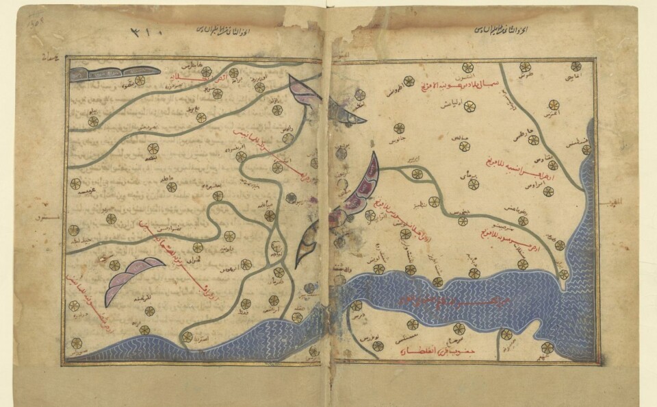
A map depicting Normandy in the 12th century has ignited huge public interest, much to the surprise of the university lecturer who shared it on social media.
Dr Christophe Maneuvrier, from Caen-Normandy University, asked followers on X (formerly known as Twitter) for help translating the map from Arabic to French in the context of his history research.
The map, made by Al-Idrissi, an Arab geographer, is one of the oldest representations of Normandy and the oldest that is similar to maps today.
It comes from an atlas known in academic circles for being one of the earliest representations of Europe but virtually unknown to the wider public.
However, the Normandy map has not been studied much.
Read more: Tiny Normandy commune to mark crucial role in D-Day landings
Al-Idrissi would send out witnesses to verify information
A work depicting France exists from the 4th century but is said to be more an oeuvre than a map.
It shows Roman itineraries and was drawn with different rules to this map.
The next realistic map to depict Normandy and the rest of northern France dates from 400 years after Al-Idrissi’s.
Advertisement
He made the map while residing in the court of King Roger II of Sicily, who asked him to make an atlas of the known world.
Named The Excursion of One Eager to Penetrate the Distant Horizons, more commonly known as the Book of Roger, it comprises 70 maps and is accompanied by a book with extra information, such as descriptions and itineraries.
Al-Idrissi relied on personal experiences as well as detailed interviews with travellers who came to Palermo.
He would only retain information he deemed trustworthy and sent out witnesses to verify it.
The Channel, towns and rivers in broadly the right place
Since it is an Arabic map, the south is depicted on top and the north on the bottom. All the names are in Arabic.
Dr Maneuvrier found it “incredible” that the representation is fairly accurate, with towns, the Channel and rivers in broadly the right place.
Al-Idrissi describes Mont-Saint-Michel as a town that attracts many people.
Today, both Bretons and Normans claim it as theirs – but to the 12th-century geographer, it is clearly in Norman territory.
Read more: Seven facts about France's Mont-Saint-Michel abbey as it turns 1,000
Surprised by the interest from the public
A researcher in Arabic languages at the same university as Dr Maneuvrier has now come forward to offer translation help.
Together, they will try to work out the author’s intentions, how he advanced his work, how Norman towns were known to him and how he transcribed them to Arabic. The process could take months.
Dr Maneuvrier said he has been taken by surprise by the reaction of the general public.
He likened posting on X to sending out a “message in a bottle”, and hoped at best that a helpful historian might come across it.
It has been viewed almost 30,000 times.
Related articles
SEE: The medieval 'bastide' villages of south-west France
How French medieval craftsmen made the stained glass windows of Troyes
French Palaeolithic cave art shows deep human connection with animals