-
Meat withdrawn from French supermarkets over E.Coli risk
Lidl and Super U among stores selling potentially impacted ground beef
-
Ryanair becomes most popular carrier at Toulouse airport
Several low-cost carriers are targeting the French city with route expansions
-
New reports of Britons missing flights due to EES delays
Queues of several hours reported in Spain prior to full EES rollout
Hautes-Alpes: ‘Snow Plan’ launches in Briançon to keep access open
Plans Neige involve measures to make it easier to visit winter resorts at times of heavy snowfall

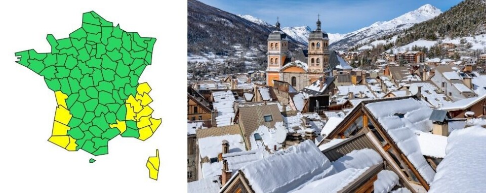
A ‘Snow Plan’ (Plan Neige) has been triggered for the town of Briançon in Hautes-Alpes as Météo France forecasts heavy snowfall in the department.
Snow Plans are a series of measures – such as free parking or increased public transport services – launched by local authorities in the hope of ensuring that cars of people visiting winter resorts do not block roads, so keeping them clear for snow ploughs and emergency vehicles if necessary.
The measures also encourage people to visit an area but avoid driving, reducing the risk of road accidents in snowy and icy conditions.
Briançon is the highest city in France and one of the highest in Europe, at an altitude of 1,326m (4,350m) above sea level.
Around the town, access to the Prorel car park will be free until tomorrow (February 15) at 09:00, and buses will be free all day today.
For residents of Hautes-Alpes, Alpes-de-Haute-Provence and Alpes-Maritimes, Isère, Savoie and Drôme, a yellow Météo France weather alert for snow and ice is in place.
📢Vigilance 🟡jaune ❄️"neige-verglas"❄️ lundi 14 février à partir de 14 h.
— Préfet des Alpes-Maritimes🇫🇷 (@prefet06) February 13, 2022
➡️Soyez prudents et tenez-vous informés avant tout déplacement. pic.twitter.com/8uPBnS0D3w
Météo Côte d’Azur predicts that there will be 20-40mm of precipitation on lower ground and 50-60mm on higher ground today (February 14) or 70mm in certain places.
The rain will turn to snow at 1,000-1,200m, with 30-50cm accumulating between 1,600 and 1,800m.
Météo France’s yellow weather warning will last all day. Residents do not need to change their behaviour but should take extra care if engaging in activities which could be made more dangerous by the snow.
In January, only 10mm of rain fell in Alpes-Maritimes, making it one of the driest months ever in the department. On February 10, the snow coverage had passed below the 1989 record, dropping below 10% of the normal level, Météo France meteorologist Gaétan Heymes wrote on Twitter.
Across the southern Alps, there is an average of only 40cm of snow on some mountains.
This period of precipitation will therefore be welcome to ski resorts in the southern Alps, although by tomorrow it is expected to have come to an end.
Related articles
Cypress pollen alert in southeast France as allergy risk arrives early
Gardening in France: The history of Toulouse’s Parma violets


