-
La Voie Bleue: European Cycle Route of the Year is in France
700km bike path linking Luxembourg and Lyon has been crowned winner of the 2026 title
-
MAP: See how your location in France affects online food shop prices
New analysis shows how your shop compares on average
-
Further sightings of processionary caterpillars in France prompt action from local authorities
Caterpillars have arrived early after mild winter
New map shows South and Corsica are untamed, wildest parts of France
Researchers have pinpointed areas of unspoiled nature on the first map of its kind for France, which could help protect biodiversity for years to come

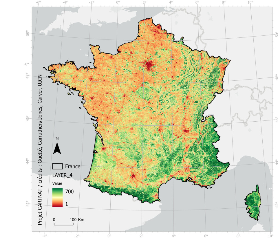
Cartographers from Britain and France have created a map of France highlighting the wildest parts of the country least impacted by human intervention.
Although the less accessible mountainous regions stand out strongly, researchers were surprised to find a variety of small seemingly wild areas spread out over French soil.
Some of them, such as that west of the Causses du Quercy, are currently afforded no protection at all.
The map uses a colour gradient ranging from green (most natural) to red (man-made), through yellow and orange.
The densest concentration of green areas, among the 10% most natural areas of France, are concentrated around the south and southeast. Corsica appears almost entirely in green.
Satellite imagery and historical maps
First of all, researchers needed to determine the ‘wildness’ of every location on the map based on geographic data.
They did this using three main criteria: landscape integrity (considering how it might look in the absence of human intervention), the degree of autonomy left to nature and ecological continuity.
Alongside 18th and 19th century maps, satellite imagery was used to help measure the amount of development, the distance to roads and any other human infrastructure.
National interest in protecting biodiversity
"The naturalness map is available to local decision-makers to help them design new protected areas," Jonathan Carruthers-Jones, a researcher at the University of Leeds and one of those involved with the project, told Le Figaro.
The map was presented at the IUCN World Conservation Congress in Marseille and by identifying parts of the country least impacted by human activity, should be useful in supporting Emmanuel Macron’s pledge to keep a third of the country’s protected areas all natural.
Related articles
French government fined record €10m for inaction on air pollution
How climate change will affect major cities in France by 2050


