-
Weekend congestion expected as France lifts fuel tanker ban
Disruptions predicted in south-east France as school holiday traffic and HGVs take to the roads
-
French arts hamlet bought for €152k now for sale for €2m
Hameau de la Brousse, in Charente, comprises five houses and two stables
-
Ikea to open smaller outlets in French towns
Swedish furniture company aims to reach more people
Strange skies above central France: What is an ‘arcus’ cloud?
The long, imposing cloud appeared as the area was on alert for thunderstorms, prompting weather experts to explain why and how these formations occur
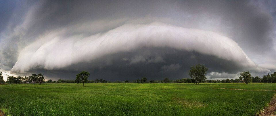
Weather experts have sought to explain the appearance of a rather ominous, long grey cloud that was photographed above Eure-et-Loir in central France yesterday (September 5). It was, in fact, an ‘arcus’ cloud.
The imposing cloud was seen as the Eure-et-Loir, Loiret, and Cher departments (Centre-Val de Loire) were under an orange weather warning for storms.
[Arcus ce lundi matin en Eure-et-Loir] Imposant et superbe #arcus photographié ce lundi matin, à l'avant d'un #orage, en #EureEtLoir, depuis Auneau. Photo : Audrey Mélou pour Météo Centre. pic.twitter.com/vmTvzfh5FK
— Association Météo Centre - Val de Loire (@AssoMeteoCVDL) September 5, 2022
And while it may have looked unusual, weather experts have said that it is a not-uncommon phenomenon.
Olivier Renard, president of the Météo Centre association, told France 3: “A cumulonimbus, or thundercloud, sets off an ascending hot air current and a descending cold air current.
“At the boundary between these two currents, a condensation of humidity takes place and this roll-shaped cloud appears [under the storm cloud].”
However, the clouds do not appear every time a storm cloud approaches. Mr Renard said: “An arcus cloud will not appear if it’s only a relatively weak storm.”
Arcus clouds can therefore be seen as a harbinger of strong storms to come, and they are often the location in which the strongest lightning and thunder can occur. Yet, Mr Renaud said that they are nothing to worry about, beyond the usual pre-storm preparations.
At the time of writing, the Loiret and Cher departments have now passed to a lower yellow alert, although neighbouring departments of Yonne, Nièvre, and Allier are still on orange alert, along with 24 other departments in the east.
Read more: Storm alerts for 27 central, eastern and southern French departments
It comes after a similar arcus cloud appeared in Indre in mid-May.
At the time, Mr Renard said that this had happened because of “surprisingly strong storms”, which caused 40% of the typical monthly rainfall to come down “in just two hours”.
Related articles
Hot weather and storms expected in France today
South of France prepares for violent storms
Incoming storms expected to put an end to France’s latest heatwave