-
Brittany beach ranked among the world’s most beautiful - but you cannot visit
Visitors entering the turquoise shoreline risk a fine
-
Normandy D-Day beaches gain UNESCO World Heritage status
Cathar castles also added as ‘Royal Fortresses of Languedoc’
-
Why one south-west France village is overrun by mosquitoes
'Several thousand larvae per square metre' in lake after flooding
Haute-Garonne and Tarn on orange weather alerts for strong winds
Wind speeds could reach 110-120km/h tonight (April 11) in certain areas
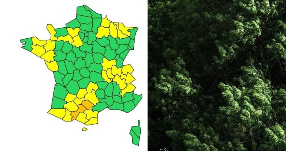
Haute-Garonne and Tarn (Occitanie) are being placed under orange weather warnings today (April 11), as the departments brace themselves for a night of very high winds.
🔶 2 dpts en #vigilanceOrange
— VigiMétéoFrance (@VigiMeteoFrance) April 11, 2022
Restez informés sur https://t.co/rJ24zzmmy4 pic.twitter.com/Mgx3fkeiAY
Wind speeds are expected to reach 80-90km/h in the south of Tarn and 110-120km/h in the foothills of the Montagne Noire, the area around Castres and towards Toulouse and Carcassonne.
This is due to the Autan wind, which blows from the south west of France, generally affecting the Languedoc and Guyenne – spreading across the more northerly areas of Occitanie and Nouvelle Aquitaine – two or three times a year.
Gusts of 60-70km/h have already been observed between Castres and Toulouse, and of 80-90km/h in the Montagne Noire foothills.
The weather alert will take effect at 18:00 this evening and last at least until 06:00 tomorrow morning (April 12).
The departments surrounding Haute-Garonne and Tarn are also under a yellow alert for strong winds.
It is expected that the wind will die down over the course of tomorrow afternoon, with conditions returning to normal by nightfall.
🟠 #VigilanceOrange #Ventsviolents
— Préfet d'Occitanie et de la Haute-Garonne (@PrefetOccitanie) April 11, 2022
De fortes rafales de vent sont attendues en #HauteGaronne à partir de 18h
⛱ Pensez à rentrer tout mobilier qui pourrait être emporté
🚗 Limitez vos déplacements et adaptez votre vitesse
📲 Restez informés de l’évolution de la situation pic.twitter.com/a6HgXtnLGR
Toulouse’s mairie has decided to close certain public parks considered to be “at risk” as a result of the wind.
Do I need to do anything?
The wind could cause electricity and telephone line issues, as well as disrupting road traffic.
Local residents should watch out for falling branches and roof tiles, and are advised to limit their movements if possible.
It is also recommended that people secure any possessions which could be blown away.
You can find out more on the Météo France website.
Related articles
Storms, avalanches - and a record 26.1C: All in same day in France
French lottery winner uses €200m fortune to fight climate change