-
French weekend weather forecast April 11 - 12: brutal temperature drop
Maximum temperatures to drop by around 10C in many regions. Rain and storms also forecast
-
France to cover the cost of cadmium exposure testing
Under new rules the cost of screening for exposure to the carcinogenic metal will be covered by health insurance
-
New AI sensors developed in Grenoble track arrival of pollen in France
With pollen levels on the rise, The Connexion talks to Oberon Sciences about its new smart sensors
Storm alerts for central-east and north-east France
Météo France has predicted thunderstorms, wind gusts of up to 80kph and rainfall of up to 80mm in a few hours, and warned residents to be particularly alert

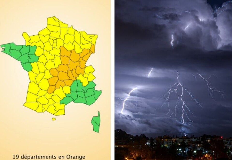
Storm alerts have been extended across much of central-east France today (June 27), with Météo France placing 19 departments on ‘orange’ (second-most severe) alert for storms, and seven for rain.
The forecaster has termed the weather a “strong summer storm that requires particular vigilance”. There is a “strong risk of violent phenomena, and a risk of heavy rainfall”, it said.
The departments on storm alert are:
Ain, Allier, Cantal, Corrèze, Côte-d'Or, Creuse, Doubs, Jura, Loire, Haute-Loire, Lot, Nièvre, Puy-de-Dôme, Haut-Rhin, Rhône, Haute-Saône, Saône-et-Loire, Yonne and Territoire de Belfort.
🔶 19 dpts en #vigilanceOrange
— VigiMétéoFrance (@VigiMeteoFrance) June 27, 2021
Restez informés sur https://t.co/rJ24zzmmy4 pic.twitter.com/qlOzjuopLO
Météo France said: “This Sunday (June 27), rain and storms will continue in several regions. Isolated storms with hailstorms and strong wind gusts will occur from the afternoon from the Auvergne to the Lyonnais and the Jura, and will then rise towards the northeast of the country.”
Storms are also expected later in the evening in the southwest, from the Massif Central to Bourgogne.
There will be thunderstorms and gusts of wind of up to 60-80 kph, and “significant and persistent rainfall”, the forecaster said. “Rainfall of up to 30-50mm is expected, and could reach 60mm or even 80mm in some areas, some of which are already waterlogged.”
The situation is expected to improve overnight tonight and into tomorrow (Monday, June 28).
Related stories
French weather: Floods, tornados, hailstones...and now snow in June
Mini-tornado rips off roof as more extreme weather hits France


