
-
France municipal elections: mixed results for the far-right and far-left
Far-right breakthrough in Nice but fall short in major cities in second round
-
Thefts of fuel on increase as prices remain over €2 a litre in France
High prices prompt rise of black market in many areas
-
Self-driving buses to arrive in France in next six months
Final testing of the vehicles is currently underway
32 departments in southwest and central France on orange storm alert
Heavy winds, rain and hail are expected to move from Occitanie to Île-de-France over the course of the afternoon. There is also a flood warning for Aude
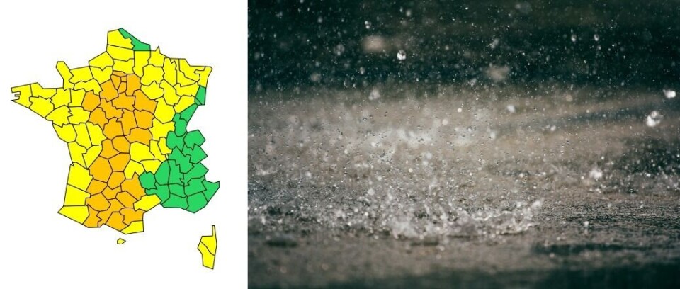
Météo-France has placed 32 departments – from Occitanie to Île-de-France – under an orange storm alert which will continue until at least 6:00 tomorrow (September 9).
There are four levels of weather alert in France: green (no vigilance needed), yellow (be vigilant), orange (be very vigilant) and red (total vigilance).
For these areas, the national weather service predicts a “stormy episode which is not unusual for the current season, but which could become more violent in some areas (with surface runoff, hail and strong winds).”
Read more:Meteo-France will give certified proof of a storm for insurance claims
🔶 32 dpts en #vigilanceOrange
— VigiMétéoFrance (@VigiMeteoFrance) September 8, 2021
Restez informés sur https://t.co/rJ24zzmmy4 pic.twitter.com/mrCIM8XUi0
The storms are set to start at the beginning of this afternoon, moving from the west of Occitanie to Limousin and Centre Val de Loire and bringing heavy rain and winds of 80-100 km/h.
By the end of the afternoon, it will reach the Paris region, the north of Auvergne and the Midi Toulousain.
Advertisement
People in the southern areas affected can expect 40-60mm of rain in three or four hours, with 60-80mm predicted for some places.
These storms could cause flooding in cellars and low-lying points, and forest fires could begin if lightning strikes woodland without being accompanied by rain.
During the storm, people are advised to stay away from trees – under which you are 50 times more likely to be struck by lightning – and bodies of water.
You should also avoid driving round in your car or parking under a tree, although vehicles can be a good shelter from thunderstorms if all the windows are closed and the radio antenna is taken down.
The most secure place to be during a storm is inside your home or another permanent building, having secured any items that may be exposed to the wind and rain.
The departments concerned are: Allier, Aude, Ariège, Aveyron, Cher, Corrèze, Creuse, Dordogne, Eure-et-Loir, Haute-Garonne, Gers, Indre, Indre-et-Loire, Loir-et-Cher, Loiret, Lot, Lot-et-Garonne, Nièvre, Hautes-Pyrénées, Sarthe, Paris, Seine-et-Marne, Yvelines, Tarn, Tarn-et-Garonne, Haute-Vienne, Yonne, Essonne, Hauts-de-Seine, Seine-Saint-Denis, Val-de-Marne et Val-d'Oise.
Aude is also on an amber alert for flooding, with 100-120mm of rain forecast to fall over three hours in the north of the department tonight.
This stormy weather comes after southwestern areas experienced a late burst of summer this week, with temperatures of 36°C recorded yesterday (September 7) in Gironde.
The heat is not expected to last into the second half of the week, with temperatures forecast to sit around 20°C in Occitanie, Centre-Val-de-Loire and Île-de-France today.
Related stories
Why a helicopter with giant antenna is flying over south west France
Drought alerts for 38 departments in France despite wet summer
South-west France edges towards 40°C before storms later this week


