-
13 people drown in France during heatwave weekend, announce authorities
Several teenagers who died were swimming in forbidden areas.
-
European beaver confirmed living in Gironde
After decades of absence, signs of the protected species have been verified near Bordeaux by France’s biodiversity agency
-
How long will the extreme heat last in France?
Red alerts to continue for much of the country with 42C forecast (in the shade) in some areas
Ferries, trains: what is known about violent storm set to hit France
Winds of up to 150 km/h are expected with the north-west particularly impacted
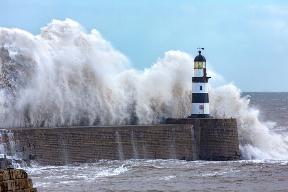
Forecasters are warning of a violent storm that is set to hit France overnight Wednesday - Thursday, bringing winds of up to 150 km/h and very high waves.
The storm, dubbed Ciarán, was already expected to hit on Wednesday evening, but now weather experts warn that it could cause more damage than initially forecast and especially in the north-west of France.
French rail operator SNCF has already announced that no trains in the region will run on between Wednesday night and Friday morning, due to the storm.
A number of ferry services have also been cancelled.
It is being caused by a so-called ‘weather bomb’ that comes from a clash of the Atlantic jet stream and a low-pressure system descending from the north of Europe, with France and the British Isles at the epicentre of the reaction.
The exact path and timeline of the storm is not yet known (although we know it will hit the northern and western coastlines particularly hard), but measures are already being put in place.
Interior Minister Gérald Darmanin cancelled his trip to Mayotte, originally planned for November 1, “in order to coordinate the mobilisation of all government services, in particular the Sécurité civile (French civil protection service)” in mainland France, he said.
Trains and ferries cancelled
Train services in the region will be cancelled due to the storm, with no services running at all in Brittany between 22:30 on Wednesday (November 1) and 05:00 Friday (November 3).
This includes both TER and TGV services, however the SNCF did state high-speed services between Paris and Rennes would still operate.
🔴Des phénomènes exceptionnels sont attendus avec des prévisions de vents violents sur toute la Bretagne dès mercredi.
— TER BreizhGo (@TERBreizhGo) October 31, 2023
Afin de garantir la sécurité des voyageurs et du personnel, une interruption totale des circulations est mise en place jeudi, toute la journée. pic.twitter.com/MMRdEjPzev
TER services in Normandy, Pays de Loire and Centre Val de Loire have also been cancelled on Thursday, although some TGV services may still be running. You should check if your journey is affected using the SNCF Connect website.
Cross-channel ferry services are also likely to be impacted by the storms.
DFDS have already cancelled a number of services between Newhaven - Dieppe and Dunkirk and Rosslare (in the Republic of Ireland) on November 2, and more could follow.
Other ferry services such as Brittany Ferries have warned passengers that cancellations and disruptions are likely, both on Wednesday November 1 and Thursday November 2.
You should keep up to date with information from ferry companies if planning to travel at this time, and they should contact you if your journey is affected.
Strong winds hundreds of miles inland
One thing that forecasters are certain of is that strong winds will be measured across France from Wednesday night onwards.
Similar to other recent storms, Ciarán will largely be controlled by a “wind tube”, around 3 kilometres wide and several thousand kilometres long.
It acts “like a train carriage on a rail,” said Météo France, driving the storm forward, with disturbances being felt either side of this “tube”.
The subsequent heavy winds could spread hundreds of miles inland into France, reaching up to 100 km/h in Paris on Thursday morning.
The English Channel and Breton coastlines will be the hardest hit, however.
“Wind speeds of 120 to 140 km/h near the Brittany coast [are expected] and peaks of up to 150 km/h locally,” said François Gourand, a leading forecaster at Météo France.
🌬️Entre mercredi soir et jeudi matin, la tempête #ciaran va toucher le quart Nord-Ouest du pays avec de très fortes rafales de vent.
— Météo-France (@meteofrance) October 30, 2023
🌊Attention également au risque de vagues submersion sur toute la façade atlantique et la Manche
Notre point complet 👉https://t.co/09XlTyKanI pic.twitter.com/UwJoUrbxRz
Winds of this magnitude could last until midday in the north-western part of France, he added.
Residents in the areas affected should be careful when outside as winds of this strength have the ability to uproot trees.
A 70-year old woman died over the weekend after a tree fell on her in eastern France.
Read more: Woman dies as weekend storms batter France: warnings continue
Coastal waves could also reach up to 10 metres in height on the Atlantic shoreline, and up to eight metres along the English Channel.
The waves will be at their highest along the Atlantic coast on Thursday morning (until around 06:00, and between midday and 14:00 along the English Channel.
Are warnings in place?
Currently, there are only three heightened alert warnings in place from Météo France for Wednesday, alongside a handful of tier-two weather warnings.
The tier-three orange alerts are for strong winds Wednesday evening in the Breton departments of Finistère, Morbihan and Côtes d'Armor.
The low level of areas currently facing a warning is due to the aforementioned uncertainty of the storm’s path, and it is highly likely more heightened warnings will be put in place over the course of today (October 31) or on Wednesday (November 1) morning.
French media outlets such as L’Express are predicting that warnings for high winds may even reach a red alert (the highest level possible) overnight on Wednesday.
You are advised to keep up with weather warnings on the Météo France website if you are in an area expected to be hit by the storm and to keep up with local weather warnings.
The emergence of storm Ciarán is set to kick off a prolonged period of wet weather in France – after the storm, rainfall is expected to touch almost all of France throughout the weekend and into next week.
Related articles
What to do (and not do) during heavy rain and flood alerts in France
Storms in France: what to do if at home, out walking or in car


