-
Small earthquake felt in southern France over the weekend
‘I thought it was a plane or an explosion at the airport’
-
Magnitude 3.3 earthquake hits Finistère – residents report loud boom
A second earthquake in a nearby commune followed a few hours later
-
Earthquake recorded in south-east France
Noise and vibration wakes Vaucluse residents after magnitude 3 quake hits near Avignon
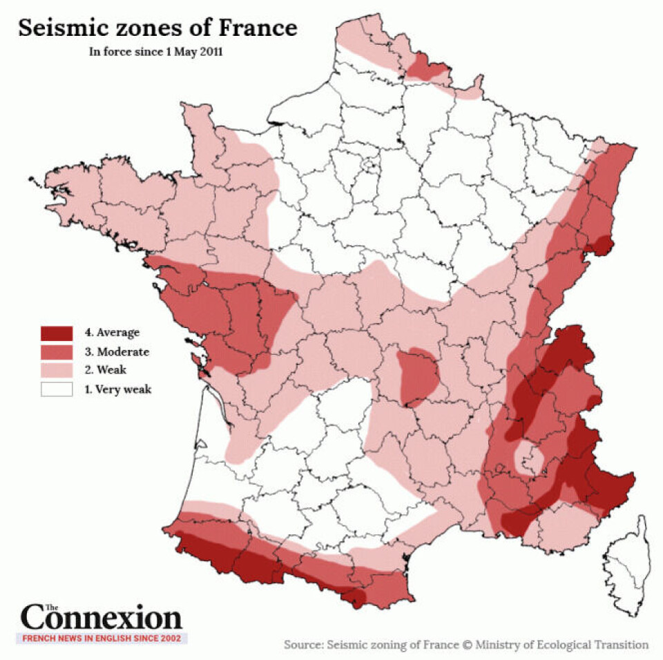
MAP: 4,000 earthquakes a year in France; where, and what risk level?
See which seismic zone your region falls under
More than 4,000 earthquakes are recorded every year in mainland France, according to France’s geographical research body Résif-Epos.
However despite this high number only around 30 of these will actually be felt by the local population.
France may be an area of frequent seismic activity, yet the risk posed by earthquakes is low compared to areas like Turkey and Syria, where a recent earthquake has caused widespread devastation and resulted in thousands of deaths.
In fact the majority of earthquakes in France are not felt by humans and are only picked up by measuring devices.
In France seismic activity is measured on 5 levels:
Very weak
Weak
Moderate
Average
Strong
In mainland France no region is marked higher than level four, with level five being reserved for overseas territories with stronger seismic activity.
Areas in and around the Pyrénées and Alps mountain ranges reach level four whereas much of the north of the country is in level one with almost no risk.
The current seismic zones have been in place in France since May 1, 2011.
The reason most seismic activity goes unnoticed in France is because it rarely registers higher than magnitude 2 or 3 on the Richter scale.
It takes a magnitude of at least 3.5 for humans to notice.
So far this year three have reached this level. They are:
-
January 27, 2023 - Dinan, Côtes-d'Armor: 3.5
-
January 17, 2023 - Barles, Alpes-de-Haute-Provence: 3.5 + 4.2
-
January 6, 2023 - Savenay, Loire-Atlantique: 3.5
Although rarer, higher magnitudes do get recorded in France, for example:
-
2019 - Teil, Ardèche: 5.4
-
2003 - Saint-Dié, Vosges: 5.4
-
1996 - Annecy, Haute-Savoie: 5.2
The last recorded earthquake to go above magnitude 6 in mainland France was in Bouches-du-Rhône in 1909. It reached 6.2 on the Richter scale with two violent evening tremors hitting villages around Rognes and Lambesc, just north of Aix-en-Provence. Forty-six people were killed and over 2,500 buildings destroyed.
To put that in perspective, the recent earthquake in Turkey and Syria was magnitude 7.8.
Realistically, there is only a slight chance of even feeling an earthquake in France, even when in the regions of increased seismic activity.
Below is a map showing the seismic zones across France:
Related articles
Unusually strong earthquake recorded in central France
Earthquake in western France: witnesses invited to file reports


