-
Woman, 70, charged over murder of British woman Karen Carter in Dordogne
Mrs Carter was stabbed eight times outside her home in 2025
-
What are carry-on liquid rules when flying from the UK or US to France?
Who sets the limits, why they were introduced, and what passengers should check before going through airport security
-
Hikers in French Pyrenees hospitalised after drinking mountain water
Why water from a mountain stream is not always safe to drink from and how to avoid dehydration
Snow and ice: 22 French departments placed on orange alert
The snowfall began last night in northern France and will spread throughout the country today and tomorrow
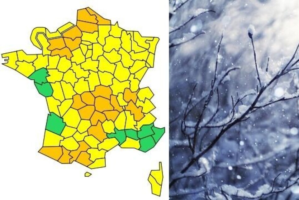
[Update April 1 at 16:35 - Pas-de-Calais, Somme, Seine-Maritime, Eure, Calvados, Nord and Orne are no longer on orange alert, while Tarn, Savoie and both Corsican departments have been upgraded to yellow to orange. This means that there are now 19 departments on an orange weather warning.]
Some 22 French departments have now been placed under an orange warning for snow and ice, as last night’s (March 31) snowfall spreads throughout the country.
When the weather makes jokes:
— Muriel FRANCIUS (@mfrancius) April 1, 2022
it's snowing on 1st of April in @Paris!#snow #neige #AprilFoolDay #AprilFoolDay2022 #PoissondAvril pic.twitter.com/V43lObzdin
The departments affected are: Ain, Allier, Ariège, Aveyron, Calvados, Cantal, Corrèze, Creuse, Eure, Haute-Garonne, Isère, Loire, Haute-Loire, Nord, Orne, Pas-de-Calais, Puy-de-Dôme, Pyrénées-Atlantiques, Hautes-Pyrénées, Seine-Maritime, Somme and Haute-Vienne.
National weather service Météo France states that the expected snowfall is “sufficiently notable to disrupt traffic and certain economic activities” and “uncommon at this time of year.”
Thury-Harcourt sous la neige ❄️ en 2021 #thuryharcourt #lehom #suissenormande #calvados #Normandie #MagnifiqueFrance pic.twitter.com/x9s8YQebbY
— Morvan Bretagne Normandie (@morvan_photo) March 31, 2022
Hauts-de-France and Normandy already under snow
Snow is already falling – and sticking – in Hauts-de-France and Normandy. There is around 1cm on the ground in Abbeville (Somme) and more on higher ground.
Along the northwestern coastline, the precipitation is mostly falling in the form of sleet.
Temperatures are still above freezing in the Alps and Jura this morning but it is already snowing across the Massif Central and the Pyrenees above 500m.
❄⛄La #neige fait son apparition en cette fin de nuit dans le #PaysBasque intérieur, collines d'Ainhice-Mongelos (260m d'alt.). Par moment a gros focons, à suivre... T° proche de 0°. #Pyrénées #EuskalHerria #BasseNavarre @Meteo_Pyrenees @ttottespelette @KeraunosObs pic.twitter.com/oaByUdDvux
— Ciel Paysage Nature (@Ciel_Paysage) April 1, 2022
Snowstorms are forecast to continue today (April 1) in Hauts-de-France and Normandy. They will last through today and into tomorrow across the Massif Central, the Pyrenees and the Alps.
Conditions should improve, starting in the east, from the end of the morning in the northern half of the country. Today’s snowfall should see 3-5cm come down, making for a total of 10cm including last night’s precipitation.
In the Alps, however, snow will begin to fall above 500m this morning. The weather will clear in the afternoon but will worsen again in the evening, continuing into tomorrow.
Several centimetres of snow is expected to fall on lower ground in Ain and Isère, and up to 20cm will cover the Chartreuse and Vercors mountains.
Over the Massif Central the snowfall will also abate after this morning, but then return in the evening and into tomorrow. On lower ground local residents can expect 5-10cm, while up to 25cm will fall above 800m.
❄ La gare de Saint-Étienne est sous la neige ce matin du 1er avril avec déjà quelques retards constatés. Il neige sur le sud et l'est du Massif Central. pic.twitter.com/v0IwGzJunb
— Météo Express (@MeteoExpress) April 1, 2022
There will be heavy snowfall in the Pyrenees this evening, with 2-5cm set to come down over low ground, 20-25cm at 800-1,000m and 15-30cm, or 50cm in some places, from 1,500-1,800m.
Accès Pas de la Casa ❄️ équipements obligatoires
— Météo Pyrénées (@Meteo_Pyrenees) April 1, 2022
Globalement il neige jusqu’en vallées dès 500m prudence 📷Patrick Baudrit via INFO/Route / Météo Pas de la Casa pic.twitter.com/eVSXH1tkgA
The orange alert will last at least until 06:00 tomorrow morning.
A further 66 departments are also on a yellow alert for snow and ice. In these places some snow could fall and stick to the ground, but no considerable disruption is expected. This will be the case, for example, in the Paris region.
La #neige est bien présente sur #Lyon ! 😍 pic.twitter.com/CU0G9zzLx6
— Lyon Météo (@LyonMeteo69) April 1, 2022
Do I need to do anything?
In areas under an orange alert, the snowfall could disrupt public transport and road travel, increasing the risk of accidents.
Local residents are advised to keep up to date with the weather conditions and limit journeys if possible.
If they do need to drive, they should take food and blankets with them in the car and make sure that it is fitted with the appropriate winter equipment.
You can find out more on the Météo France website.
Related articles
Nord and Pas-de-Calais on orange weather alerts for snow and ice
Helicopters, lanterns: French farmers prepare to beat the freeze
Water restrictions on way for south-east France in early drought alert


