-
Satellite photos reveal scale of recent wildfires in France
Before-and-after images show extent of damage
-
EasyJet cabin crew in France file strike notice
Unions act after failed talks with management
-
French railway carriage turned holiday home with its own tunnel for sale in Dordogne
‘Everyone knows me as someone who takes on projects, but this was really a bit crazy - buying a tunnel’
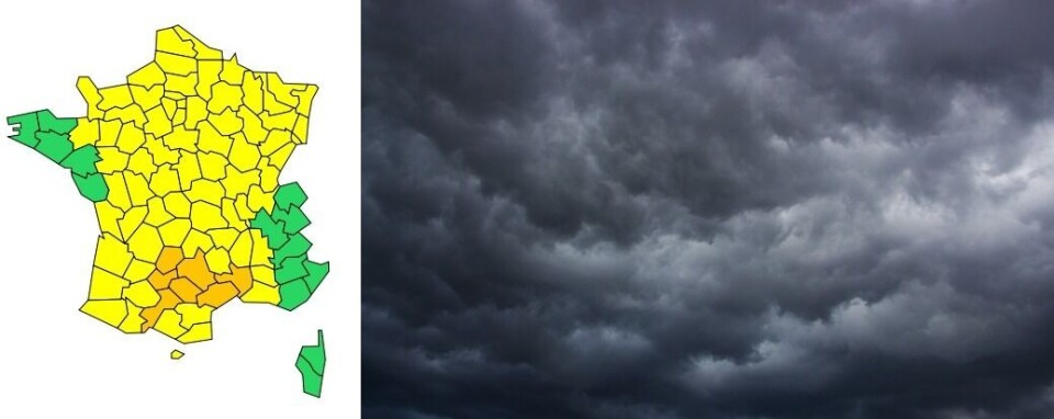
82 departments in south, central and north France on storm warnings
Much of France is under a yellow alert, while seven departments have also been placed on orange alert for heavy rain and flooding
[Update September 14 at 15:30: Gard was later placed under a red alert as nearly two months' worth of rain fell over the course of the morning. It is now back on an orange warning.]
The majority of French departments are today (September 14) under a yellow storm warning, and seven are on an orange alert.
These include Gard, Hérault, Tarn, Aveyron, Lot, Haute-Garonne and Tarn-et-Garonne.
A yellow warning brings with it a “moderate risk” of localised storms, while an orange alert represents a “moderate to strong risk” of “heavy rain with surface runoff” and winds between 75 and 100km/h.
Météo France has said that the stormy weather has been caused by the arrival of “humid and unstable air across most of the country.”
The storms will affect everywhere but the west coast, from Finistère to Vendée, and the south east from Haute-Savoie to Alpes-Maritimes, Var and Corsica.
Météo France warns that this morning will bring a stormy episode “requiring particular vigilance, as there is a real risk of a violent weather event.”
#vigilanceOrange
— Météo-France (@meteofrance) September 14, 2021
Sur Gard et Hérault, orages virulents jusqu'en mi-journée. Sur Midi-Pyrénées, risque d'orages isolés virulents cet après-midi puis axe orageux fortement précipitant à suivre à partir de ce soir.
⚠️Soyez vigilants et restez informés https://t.co/w5OGXbEEhP https://t.co/23CBz053ku
The storms will begin this morning in certain areas of Hérault and Gard, resulting in 80 to 100mm of rainfall in some areas of the departments.
People in these areas should also expect strong winds, hail and lightning, and some rail services may be affected.
The storm should abate slightly over the course of the afternoon but will continue into the early hours of Wednesday morning.
In Haute-Garonne and Tarn-et-Garonne, the storm will begin to gain momentum this afternoon, moving east across Lot, Tarn and Aveyron.
Around 30 to 40mm of rain is expected to fall in one hour in some areas, and heavy hailstorms are predicted.
Conditions are expected to grow calmer this evening, but overnight more storm clouds will move over the Pyrenees, bringing 50mm of rain over one hour in some places.
The weather should return to normal by 08:00 on Wednesday morning.
Staying safe in a storm
Météo France recommends that, in areas affected by storms, people keep away from trees, under which they are more likely to be struck by lightning and bodies of water, which conduct electricity.
The best place to shelter is in a building such as a house, after having secured any possessions that may be exposed to the wind and rain.
It is not recommended that you drive your car around, although if this cannot be avoided you should make sure that your windows are closed and the radio antenna has been removed.
Related articles
Meteo-France will give certified proof of a storm for insurance claims
Severe floods in south-west France after two months' rain in 24 hours


